 ar
ar bg
bg hr
hr cs
cs da
da nl
nl fi
fi fr
fr de
de el
el hi
hi it
it ko
ko no
no pl
pl pt
pt ro
ro ru
ru es
es sv
sv tl
tl iw
iw id
id lv
lv lt
lt sr
sr sk
sk sl
sl uk
uk vi
vi et
et hu
hu th
th tr
tr fa
fa ms
ms hy
hy ka
ka ur
ur bn
bn mn
mn ta
ta kk
kk uz
uz ku
ku
Tilt Sensor
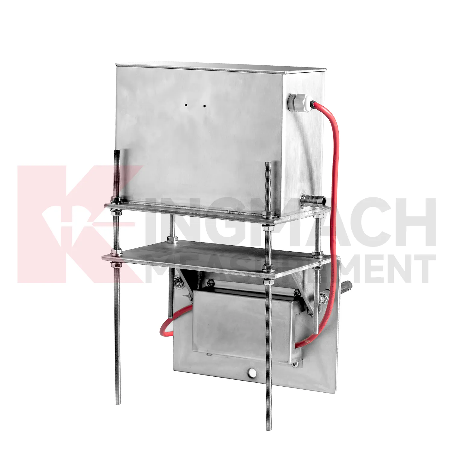
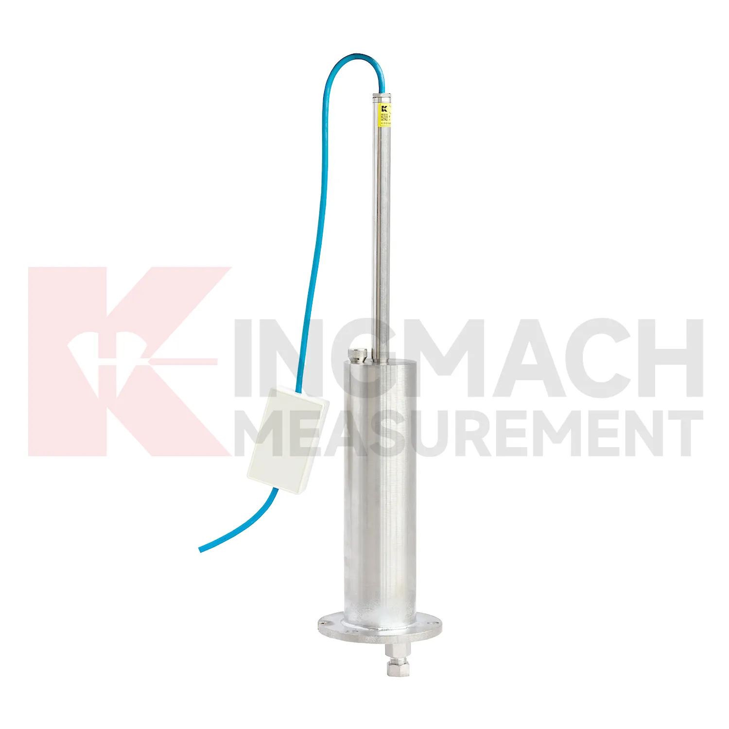
Kingmach Tilt Sensor include the JMDL-47XXAT smart single-point settlement gauge for buried positions where a defined vertical movement must be followed through construction. It is used for subgrade settlement, embankment heave, base uplift in deep foundation pits, tunnel bottom uplift, dyke compression deformation, and pile foundation settlement. Published range options are 100 mm, 200 mm, 300 mm, and 400 mm. Resolution is 0.01 mm on 100 mm and 200 mm models, and 0.1 mm on 300 mm and 400 mm models. Gauge lengths cover 760 mm, 1240 mm, 1720 mm, and 2210 mm. The assembly includes a settlement plate, electrical displacement sensor, measuring rod with metal flexible conduit, anchor head, extension rod, and bottom anchor head. Its side-exit cable design helps reduce interference during pavement compaction. The product is strongest when the installation depth, plate location, cable route, fill layer, and first stable reading are documented before the buried parts disappear under later work.
Application of Tilt Sensor
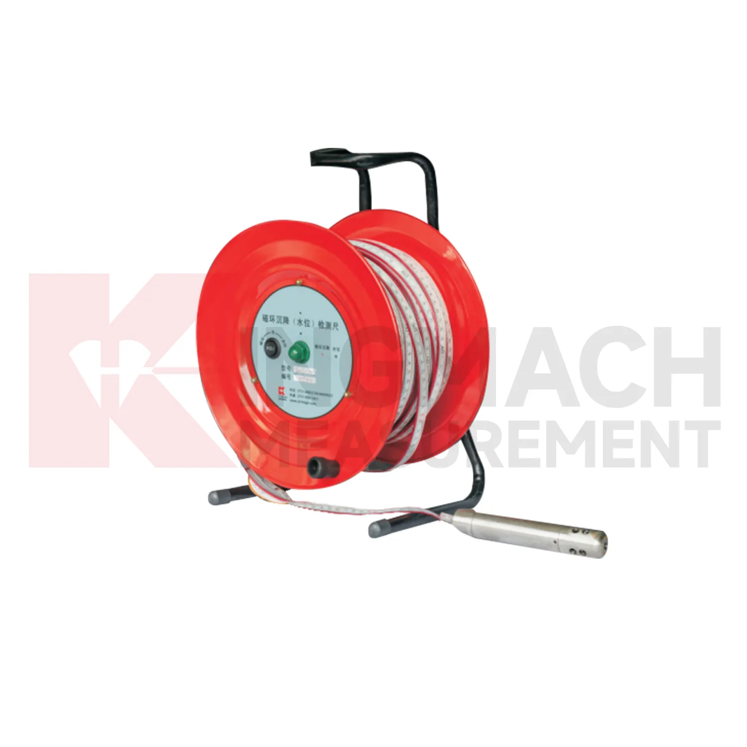
In foundation pit projects, Tilt Sensor are used during staged excavation to track base uplift, nearby pavement settlement, groundwater response, and vertical movement around retaining systems. The timing of each value matters because deformation may change after dewatering, support installation, soil removal, rainfall, or backfilling. Kingmach JMDL-47XXAT can be embedded to follow base uplift or local settlement, while JMCJ-1003/1005 can read magnetic ring depth and groundwater level in boreholes. Hydrostatic instruments may be added where several elevations around the pit need comparison against a reference. The site team should record excavation depth, support level, water pumping condition, adjacent road or building observations, and first stable baseline beside the settlement curve. If movement grows quickly, the response should include checking the sensor and reference first, then comparing support force, wall displacement, groundwater, and visual inspection before deciding whether excavation can continue. This keeps settlement review tied to the actual construction sequence, which is essential because a pit may behave differently at each excavation depth and support stage. A clear record also helps distinguish base rebound from surrounding ground loss or reference disturbance. The review file should also include reference condition, recent site work, nearby sensor behavior, and inspection notes so later teams can interpret the curve clearly.
The future of Tilt Sensor
Remote infrastructure will shape the future of Tilt Sensor. Many settlement points sit along long railways, expressways, dams, embankments, slopes, and tunnel portals where routine manual reading is expensive and sometimes unsafe. Low-power acquisition, wireless gateways, solar power, and clear cabinet layouts can reduce unnecessary visits while keeping settlement trends visible. Kingmach hydrostatic sensors and settlement gauges that support remote data collection can fit this direction, especially when RS485 channels, power supply, and reference points are documented well. Remote monitoring should still include scheduled field checks, because tubes, probes, cables, and reference points can be affected by weather and construction. The best future setup will combine fewer emergency trips with better evidence for deciding when a site visit is truly needed. The practical goal is to keep settlement data understandable after the original installation crew has left, so owners can compare old and new readings without reconstructing the field history from memory. The same record should remain readable for designers, contractors, owners, and maintenance teams, because settlement monitoring often continues long after the first construction report is finished.
Care & Maintenance of Tilt Sensor
Manual-reading Tilt Sensor should follow a repeatable procedure every visit. Use the same reference mark, reading direction, tape handling method, waiting time, and data sheet format. This is especially important for magnetic ring settlement gauges and borehole water level readings, where inconsistent field practice can create false changes. Record operator, weather, groundwater condition, borehole obstruction, battery condition, and any unusual sound or visual indication from the alert system. Do not round readings differently from one visit to the next. If manual data is later entered into software, keep the original field notes available for checking. Manual monitoring can be reliable over many years when the process is simple, dated, and boringly consistent. The goal is repeatability, not speed.
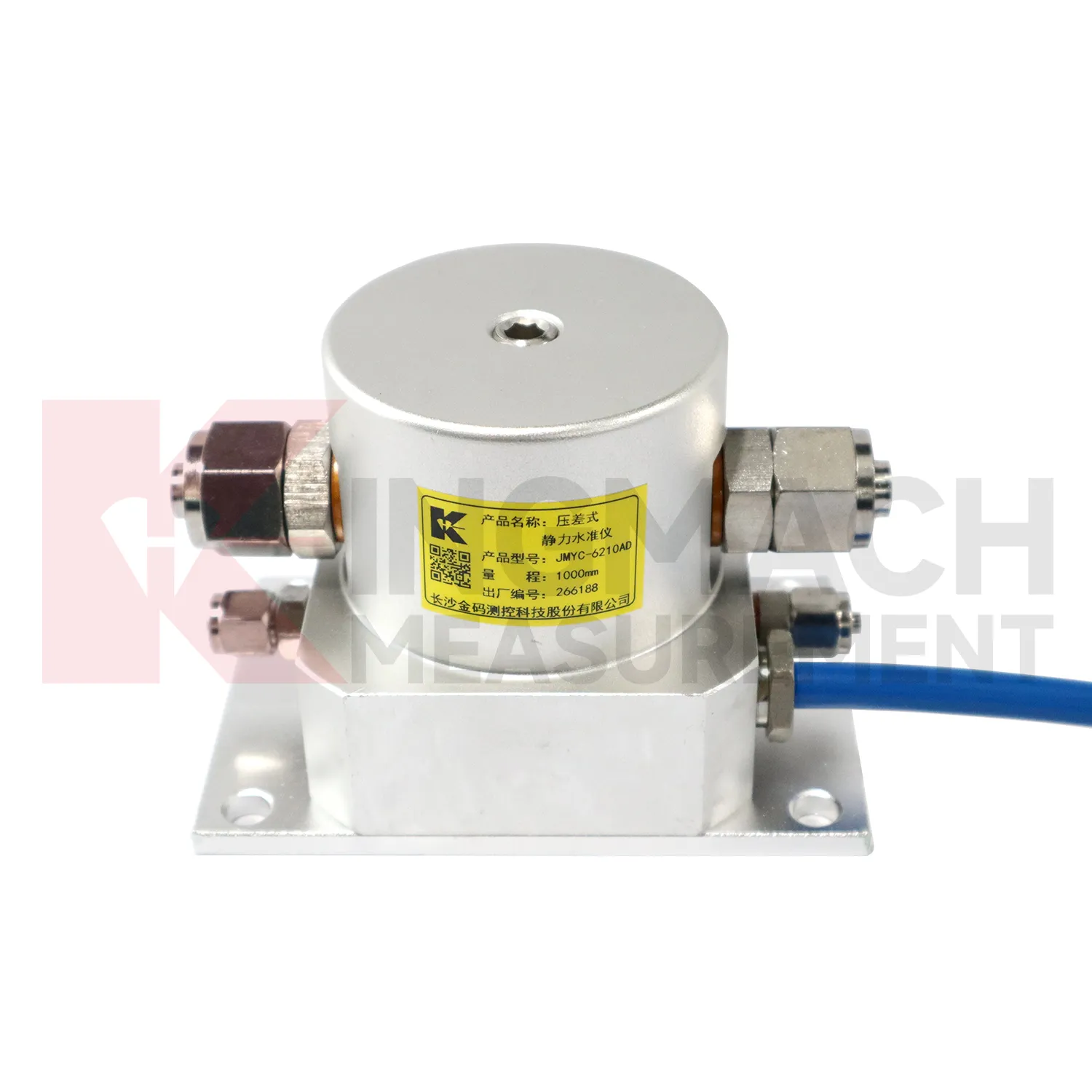
Kingmach Tilt Sensor
Tilt Sensor are used when vertical movement must be measured before it becomes visible as cracks, uneven pavement, rail irregularity, or structural distress. Kingmach settlement products cover embedded single-point measurement, hydrostatic leveling, wide-range differential pressure monitoring, magnetic ring settlement and water level reading, and micro range deflection monitoring. On a roadbed, the reading may show whether filling and compaction are stabilizing. On a bridge, it may show deflection relative to a reference point. In a foundation pit, it may show base uplift after excavation or dewatering. The key is to treat settlement as a time-based record, not a one-time survey value. Each point should carry its model, range, reference point, baseline, installation depth, and acquisition channel so later engineers can understand what moved, when it moved, and why the value matters. During review, the team should compare the value with nearby points, construction timing, water condition, and inspection notes before deciding whether the movement is acceptable.
FAQ
Q: How should Tilt Sensor be maintained?
A: Check reference points, tubes, cables, seals, settlement plates, anchors, probes, cabinets, and channel names at planned intervals.
Q: Should zero values be reset casually?
A: No. A reset can hide real settlement. If a reset is necessary, record the reason, time, old baseline, and new baseline.
Q: What data should be reviewed with settlement?
A: Rainfall, groundwater, excavation depth, filling stage, traffic loading, tilt, displacement, strain, and load data can all help explain settlement changes.
Q: What signs suggest a data issue?
A: Flat lines, sudden jumps after maintenance, impossible values, repeated communication gaps, or disagreement with nearby points may indicate instrument or data-chain problems.
Q: What makes a settlement report useful?
A: A useful report includes point location, model, range, baseline, reference point, latest reading, cumulative settlement, rate of change, and field notes.
Reviews
Christopher Martinez
Very satisfied with the readouts & data loggers. User-friendly interface and supports multiple sensor inputs.
David Wilson
We purchased displacement transducers and settlement sensors, and the quality exceeded our expectations. Easy installation and reliable performance.
Latest Inquiries
To protect the privacy of our buyers, only public service email domains like Gmail, Yahoo, and MSN will be displayed. Additionally, only a limited portion of the inquiry content will be shown.
Harper***@gmail.comIndia
Dear Sir, we are planning to procure a complete monitoring system including strain gauges, tiltmeter...
Charlotte***@gmail.comUnited Arab Emirates
Hi, we require instrumentation cables suitable for harsh environments. Could you advise on specifica...